Offshore Navigator 5.1

Offshore Navigator GPS planning and chartplotting software
5 
Rating
Your vote:
Latest version:
5.7 See all
Developer:
Maptech Inc.
Screenshots
1 / 2
Request
Download
link when available

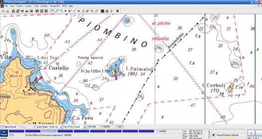
Offshore Navigator GPS planning and chartplotting software is fully compatible with Maptech/BSB charts. Use it to plan routes, print route plans and show your real-time GPS position right on the PC screen.
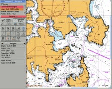
Offshore Navigator is available as a stand-alone software package for use with NOAA charts from U.S. Boating Chart DVD with Tides and Currents and is also packaged with the complete U.S. chart coverage, aerial photos, and satellite images in our Chart Navigator package.

Comments

5 stars
3
4 stars
0
3 stars
0
2 stars
0
1 stars
0
User

Your vote:

Related software

Canon MP Navigator
Canon MP Navigator
Free
rating

Enables you to scan in documents, photos or access images.

OLYMPUS A-GPS Utility
Free
rating

It can be used to download the A-GPS data for cameras.

Endeavour Navigator
Endeavour Navigator
rating

Comprehensive marine navigation software.

Universal Flight Planning
Free
rating

Allows you to perform offline GPS FDE predictions for remote/oceanic operations

Maptech Chart Navigator (with Offshore Navigator
Maptech Chart Navigator
Free
rating

Offshore Navigator provides the tools for route and trip planning and navigating